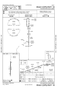


M70 - Pocahontas Muni
Located in Pocahontas, United States
ICAO - M70, IATA -
Data provided by AirmateGeneral information
Coordinates: N36°14'44" W90°57'19"
Elevation is 273 feet MSL.
Magnetic variation is -01° East View others Airports in Arkansas
Operational data
Special qualification required
Current time UTC:
Current local time:
Weather at : KARG - Walnut Ridge Rgnl ( 14 km )
METAR: KARG 022356Z AUTO 14008KT 10SM SCT080 OVC100 21/19 A2984 RMK AO2 RAE10 SLP104 P0001 60002 T02110194 10278 20200 58000
Communications frequencies: [VIEW]
Runways:
| RWY identifier | QFU | Length (ft) | Width (ft) | Surface | LDA (ft) |
| 18 | 181° | 4000 | 75 | ASPH | |
| 36 | 1° | 4000 | 75 | ASPH |
Airport contact information
Address: Pocahontas United States