


M45 - Alpine County
Located in Markleeville, United States
ICAO - M45, IATA -
Data provided by AirmateGeneral information
Coordinates: N38°44'5" W119°46'1"
Elevation is 5872 feet MSL.
Magnetic variation is 16° East View others Airports in California
Operational data
Special qualification required
Current time UTC:
Current local time:
Weather at : KTVL - Lake Tahoe ( 27 km )
METAR: KTVL 141453Z AUTO 00000KT 10SM CLR 08/04 A3013 RMK AO2 SLP162 T00830044 51003
TAF: KTVL 141120Z 1412/1512 18003KT P6SM SKC FM141800 03007KT P6SM SCT080 SCT220 FM150200 VRB03KT P6SM FEW220
Communications frequencies: [VIEW]
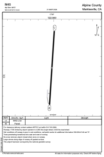
Runways:
| RWY identifier | QFU | Length (ft) | Width (ft) | Surface | LDA (ft) |
| 17 | 184° | 4443 | 50 | ASPH | |
| 35 | 4° | 4443 | 50 | ASPH |
Airport contact information
Address: Markleeville United States