


M44 - Houston Muni
Located in Houston, United States
ICAO - M44, IATA -
Data provided by AirmateGeneral information
Coordinates: N33°53'11" W89°1'23"
Elevation is 337 feet MSL.
Magnetic variation is 02° East View others Airports in Mississippi
Operational data
Special qualification required
Current time UTC:
Current local time:
Weather at : KTUP - Tupelo Rgnl ( 48 km )
METAR: KTUP 031953Z 28004KT 10SM FEW040 BKN049 BKN060 26/21 A2994 RMK AO2 SLP136 T02560206
TAF: KTUP 031936Z 0320/0418 24004KT P6SM VCSH SCT030 BKN045 TEMPO 0320/0322 VRB10G20KT 3SM TSRA BKN035CB FM032330 VRB03KT P6SM FEW045 BKN070 FM040500 00000KT 6SM BR BKN015 FM040800 00000KT 3SM BR OVC005 FM041500 23004KT P6SM BKN012
Communications frequencies: [VIEW]
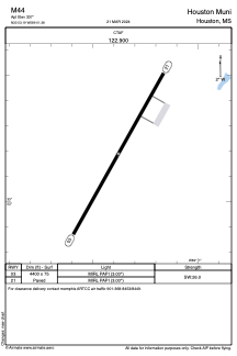
Runways:
| RWY identifier | QFU | Length (ft) | Width (ft) | Surface | LDA (ft) |
| 03 | 29° | 4400 | 75 | ASPH | |
| 21 | 209° | 4400 | 75 | ASPH |
Airport contact information
Address: Houston United States