


LTFM - Istanbul
Located in Istanbul, Turkey
ICAO - , IATA - IST
Data provided by AirmateGeneral information
Coordinates: N41°16'31" E28°45'7"
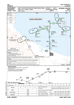
Elevation is 325 feet MSL.
Magnetic variation is 5.4° East View others Airports in Istanbul
Operational data
Special qualification required
Current time UTC:
Current local time:
Weather
METAR: LTFM 050720Z 03016KT 9999 FEW014 BKN023 15/11 Q1017 NOSIG RMK RWY17L 03015KT RWY34L 03014KT RWY16R 02014KT RWY36 04017KT RWY18 04015KT
TAF: TAF LTFM 050440Z 0506/0612 03015KT 9999 SCT008 BKN025 TEMPO 0506/0508 -SHRA FEW017CB BKN025 BECMG 0508/0510 SCT035 BECMG 0510/0512 CAVOK BECMG 0518/0521 VRB02KT BECMG 0605/0608 06012KT
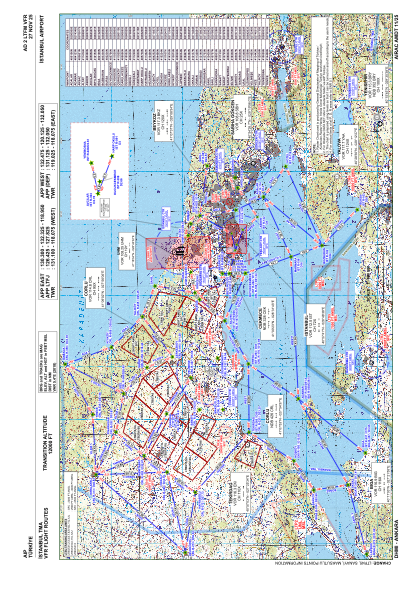
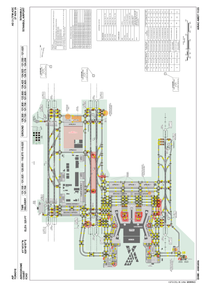
Communications frequencies: [VIEW]
Runways:
| RWY identifier | QFU | Length (ft) | Width (ft) | Surface | LDA (ft) |
| 16R | 179° | 12303 | 197 | ASPH | 12303 |
| 34L | 359° | 12303 | 197 | ASPH | 12303 |
| 16L | 179° | 12303 | 148 | ASPH | 12303 |
| 34R | 359° | 12303 | 148 | ASPH | 12303 |
| 17L | 179° | 13451 | 197 | ASPH | 13451 |
| 35R | 359° | 13451 | 197 | ASPH | 13451 |
| 17R | 179° | 13451 | 148 | ASPH | 13451 |
| 35L | 359° | 13451 | 148 | ASPH | 13451 |
| 18 | 179° | 10039 | 148 | CONC+ASPH | 10039 |
| 36 | 359° | 10039 | 148 | CONC+ASPH | 10039 |
Airport contact information
Address: Istanbul Turkey