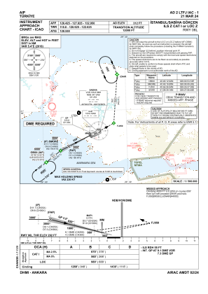
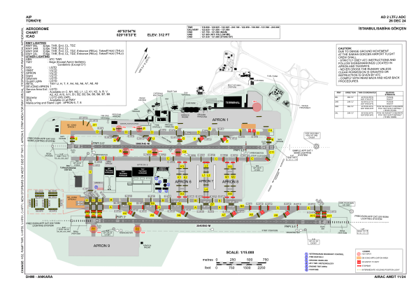


LTFJ - Istanbul Sabiha Gokcen
Located in Istanbul, Turkey
ICAO - LTFJ, IATA - SAW
Data provided by AirmateGeneral information
Coordinates: N40°53'54" E29°18'33"
Elevation is 312 feet MSL.
Magnetic variation is 5.4° East View others Airports in Istanbul
Operational data
Special qualification required
Current time UTC:
Current local time:
Weather
METAR: LTFJ 282020Z 06011KT 9999 BKN003 BKN020 14/13 Q1021 NOSIG RMK RWY24R 05009KT RWY06R 03012KT RWY24L 03011KT
TAF: TAF AMD LTFJ 282024Z 2820/2918 05012KT 9999 BKN003 BKN020 TEMPO 2902/2906 3200 -SHRA BR BECMG 2906/2909 -SHRA TEMPO 2908/2912 05015G25KT
Communications frequencies: [VIEW]
Runways:
| RWY identifier | QFU | Length (ft) | Width (ft) | Surface | LDA (ft) |
| 06L | 64° | 9843 | 148 | CONC | 9547 |
| 24R | 244° | 9843 | 148 | CONC | 9843 |
| 06R | 64° | 11614 | 197 | CONC+ASPH | 11614 |
| 24L | 244° | 11614 | 197 | CONC+ASPH | 11614 |
Airport contact information
Address: Istanbul Turkey