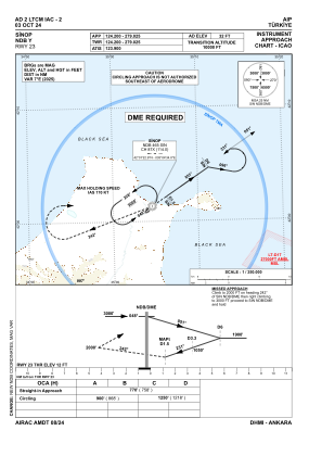
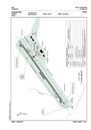


LTCM - Sinop
Located in Sinop, Turkey
ICAO - LTCM, IATA - NOP
Data provided by AirmateGeneral information
Coordinates: N42°0'57" E35°3'59"
Elevation is 32 feet MSL.
Magnetic variation is 6.2° East View others Airports in Sinop
Operational data
Special qualification required
Current time UTC:
Current local time:
Weather
METAR: LTCM 280750Z 29013KT 9999 FEW014 SCT100 17/13 Q1018
TAF: TAF LTCM 280740Z 2809/2818 31012G23KT 9999 SCT030 BKN100 TEMPO 2815/2818 -SHRA BKN028 BKN080
Communications frequencies: [VIEW]
Runways:
| RWY identifier | QFU | Length (ft) | Width (ft) | Surface | LDA (ft) |
| 05 | 54° | 6562 | 148 | CONC | 6562 |
| 23 | 234° | 6562 | 148 | CONC | 6562 |
Airport contact information
Address: Sinop Turkey