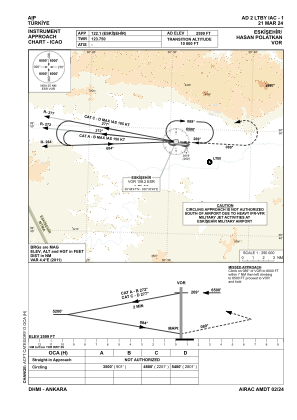
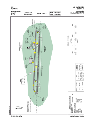


LTBY - Eskisehir Hasan Polatkan
Located in Eskisehir, Turkey
ICAO - LTBY, IATA - AOE
Data provided by AirmateGeneral information
Coordinates: N39°48'45" E30°31'14"
Elevation is 2599 feet MSL.
Magnetic variation is 5.4° East View others Airports in Eskisehir
Operational data
Special qualification required
Current time UTC:
Current local time:
Weather
METAR: LTBY 060650Z VRB03KT CAVOK 10/M03 Q1016
TAF: TAF LTBY 060440Z 0606/0615 24008KT CAVOK BECMG 0606/0608 34012KT
Communications frequencies: [VIEW]
Runways:
| RWY identifier | QFU | Length (ft) | Width (ft) | Surface | LDA (ft) |
| 09 | 93° | 9843 | 148 | CONC | 9843 |
| 27 | 273° | 9843 | 148 | CONC | 9843 |
Airport contact information
Address: Eskisehir Turkey