


LTBA - Istanbul Ataturk
Located in Istanbul, Turkey
ICAO - LTBA, IATA - ISL
Data provided by AirmateGeneral information
Coordinates: N40°58'34" E28°48'51"
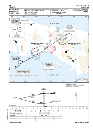
Elevation is 94 feet MSL.
Magnetic variation is 5.4° East View others Airports in Istanbul
Operational data
Special qualification required
Current time UTC:
Current local time:
Weather at : LTFM - Istanbul ( 34 km )
METAR: LTFM 162020Z 09009KT 050V120 CAVOK 14/09 Q1022 NOSIG RMK RWY17L 09015KT RWY34L 08013KT RWY16R 09014KT RWY36 08012KT 040V100 RWY18 09013KT
TAF: TAF LTFM 161640Z 1618/1724 08010KT CAVOK BECMG 1618/1621 SCT035 BKN100 PROB30 TEMPO 1621/1624 -SHRA BKN030 BKN100 PROB30 TEMPO 1700/1703 -SHRA BKN030 BKN100 BECMG 1704/1707 07017G27KT CAVOK BECMG 1716/1719 04010KT
Communications frequencies: [VIEW]
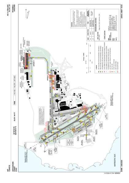
Runways:
| RWY identifier | QFU | Length (ft) | Width (ft) | Surface | LDA (ft) |
| 05 | 59° | 8465 | 197 | ASPH | 8038 |
| 23 | 239° | 8465 | 197 | ASPH | 8465 |
Airport contact information
Address: Istanbul Turkey