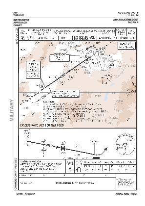
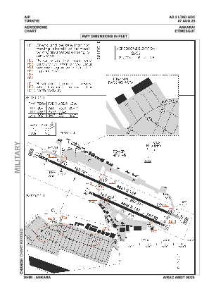


LTAD - Ankara Etimesgut
Located in Ankara, Turkey
ICAO - LTAD, IATA - ANK
Data provided by AirmateGeneral information
Coordinates: N39°57'6" E32°41'15"
Elevation is 2653 feet MSL.
Magnetic variation is 5.9° East View others Airports in Ankara
Operational data
Special qualification required
Current time UTC:
Current local time:
Weather
METAR: LTAD 300507Z 31003KT 280V360 9999 -SHRA SCT040 BKN100 BKN200 15/14 Q1019 NOSIG RMK RWY29 VRB02KT
TAF: TAF LTAD 300440Z 3006/3015 VRB02KT 9999 SCT040 SCT100 PROB30 TEMPO 3009/3013 17015G25KT -TSRA FEW025CB BKN035 TEMPO 3013/3015 23015G25KT -TSRA SCT025CB BKN035
Communications frequencies: [VIEW]
Runways:
| RWY identifier | QFU | Length (ft) | Width (ft) | Surface | LDA (ft) |
| 11 | 114° | 8061 | 138 | ASPH | 8061 |
| 29 | 294° | 8061 | 138 | ASPH | 8061 |
Airport contact information
Address: Ankara Turkey