


LTAC - Ankara Esenboga
Located in Ankara, Turkey
ICAO - LTAC, IATA - ESB
Data provided by AirmateGeneral information
Coordinates: N40°7'41" E32°59'42"
Elevation is 3127 feet MSL.
Magnetic variation is 5.6° East View others Airports in Ankara
Operational data
Special qualification required
Current time UTC:
Current local time:
Weather
METAR: LTAC 052220Z 06006KT 030V090 CAVOK 05/00 Q1014 NOSIG RMK RWY21L 05006KT 020V100 RWY03L 07005KT 040V100 RWY21R 03008KT
TAF: TAF LTAC 051640Z 0518/0618 03012KT CAVOK BECMG 0518/0521 VRB02KT BECMG 0606/0608 03012KT BECMG 0615/0618 VRB02KT
Communications frequencies: [VIEW]
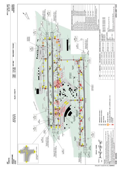
Runways:
| RWY identifier | QFU | Length (ft) | Width (ft) | Surface | LDA (ft) |
| 03L | 36° | 11125 | 148 | ASPH | 11125 |
| 21R | 216° | 11125 | 148 | ASPH | 11125 |
| 03R | 36° | 12310 | 197 | ASPH | 12310 |
| 21L | 216° | 12310 | 197 | ASPH | 12310 |
Airport contact information
Address: Ankara Turkey