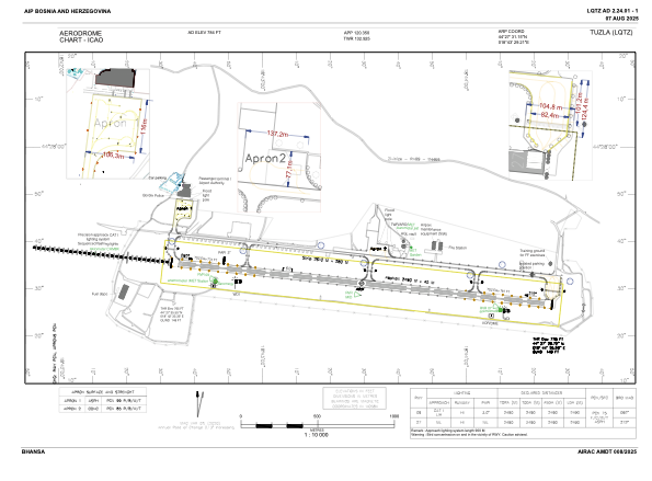


LQTZ - International Airport Tuzla
Located in Tuzla, Bosnia and Herzegovina
ICAO - LQTZ, IATA - TZL
Data provided by AirmateGeneral information
Coordinates: N44°27'31" E18°43'29"
Elevation is 784 feet MSL.
Magnetic variation is 005° East View others Airports in Federacija Bosna i Hercegovina
Operational data
Special qualification required
Current time UTC:
Current local time:
Weather
METAR: LQTZ 050630Z 29003KT 240V340 5000 2000W BR SCT003 11/11 Q1016
TAF: TAF COR LQTZ 050500Z 0506/0606 06004KT CAVOK TX25/0513Z TN09/0506Z PROB40 TEMPO 0506/0507 0400 FG BKN002 PROB30 TEMPO 0513/0519 12012KT SHRA FEW030TCU SCT040 TEMPO 0600/0606 2000 BR PROB30 TEMPO 0602/0606 0300 FG BKN001
Communications frequencies: [VIEW]
Runways:
| RWY identifier | QFU | Length (ft) | Width (ft) | Surface | LDA (ft) |
| 09 | 96° | 8169 | 148 | ASP | 8169 |
| 27 | 276° | 8169 | 148 | ASP | 8169 |
Airport contact information
Address: Tuzla Bosnia and Herzegovina