


LKCT - Chotebor
Located in Chotebor, Czech Republic
ICAO - LKCT, IATA -
Data provided by AirmateGeneral information
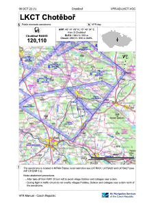
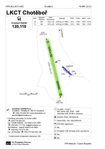
Coordinates: N49°41'9" E15°40'34"
Elevation is 1946 feet MSL.
View others Airports in Vysocina Region
Operational data
Special qualification required
Current time UTC:
Current local time:
Weather at : LKCV - Caslav ( 35 km )
METAR: LKCV 111630Z 34005KT CAVOK 20/08 Q1019 NOSIG RMK BLU BLU
TAF: TAF LKCV 111100Z 1112/1212 VRB02KT CAVOK PROB40 TEMPO 1112/1121 35010KT 7000 SHRA SCT030TCU BKN035 PROB30 TEMPO 1115/1119 01016KT 6000 TSRA SCT030CB PROB40 TEMPO 1203/1208 5000 RA BR SCT015 BKN020 BECMG 1208/1210 BKN025
Communications frequencies: [VIEW]
Runways:
| RWY identifier | QFU | Length (ft) | Width (ft) | Surface | LDA (ft) |
| 17 | 0° | 3314 | 164 | UNK | |
| 35 | 0° | 3314 | 164 | UNK |
Airport contact information
Address: Chotebor Czech Republic