


LKBOLE - Boleradice
Located in Boleradice, Czech Republic
ICAO - , IATA -
Data provided by AirmateGeneral information
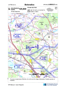
Coordinates: N48°57'43" E16°49'54"
Elevation is 649 feet MSL.
View others Airports in South Moravian Region
Operational data
Special qualification required
Current time UTC:
Current local time:
Weather at : LKTB - Brno/Turany ( 23 km )
METAR: LKTB 051230Z 20010KT 160V220 CAVOK 23/10 Q1010 NOSIG
TAF: TAF LKTB 051100Z 0512/0612 20010KT CAVOK PROB30 TEMPO 0512/0519 27016KT 4000 TSRA SCT035CB BECMG 0519/0521 VRB02KT PROB40 TEMPO 0603/0606 1300 MIFG BR BKN003 BECMG 0608/0610 18009KT
Communications frequencies: [VIEW]
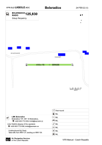
Runways:
| RWY identifier | QFU | Length (ft) | Width (ft) | Surface | LDA (ft) |
| 09 | 90° | 1345 | 49 | GRASS | 1345 |
| 27 | 270° | 1345 | 49 | GRASS |
Airport contact information
Address: Boleradice Czech Republic