


LJKAM - Kamnik
Located in Podgorje, Slovenia
ICAO - , IATA -
Data provided by AirmateGeneral information
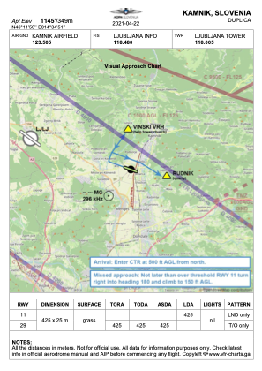
Coordinates: N46°11'50" E14°34'51"
Elevation is 1145 feet MSL.
Magnetic variation is 4° East View others Airports in Kamnik
Operational data
Special qualification required
Current time UTC:
Current local time:
Weather at : LJLJ - Ljubljana/Brnik ( 10 km )
METAR: LJLJ 090200Z 32002KT 9999 MIFG FEW013 BKN065 12/11 Q1021 NOSIG
TAF: TAF LJLJ 082300Z 0900/1000 29003KT 9999 FEW010 SCT025 BKN045 PROB30 TEMPO 0902/0907 1500 BR BKN003
Communications frequencies: [VIEW]
Runways:
| RWY identifier | QFU | Length (ft) | Width (ft) | Surface | LDA (ft) |
| 29 | 292° | 1394 | 82 | GRAS | |
| 11 | 112° | 1394 | 82 | GRAS | 1394 |
Airport contact information
Address: Podgorje Slovenia