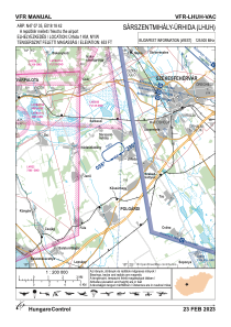
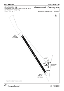


LHUH - Sarszentmihaly-Urhida
Located in Sarszentmihaly, Hungary
ICAO - , IATA -
Data provided by AirmateGeneral information
Coordinates: N47°7'35" E18°18'42"
Elevation is 653 feet MSL.
View others Airports in Fejér
Operational data
Special qualification required
Current time UTC:
Current local time:
Weather at : LHPA - Papa ( 67 km )
METAR: LHPA 030315Z 19002KT 9999 -SHRA SCT050TCU BKN083 12/11 Q1007 TEMPO 6000 SHRA RMK BLU
TAF: TAF LHPA 022315Z 0300/0324 12006KT CAVOK TEMPO 0300/0315 6000 SHRA -RA SCT035TCU BKN063 TEMPO 0301/0308 VRB03KT PROB30 TEMPO 0302/0307 5000 BR -RA BKN010 BKN030 BECMG 0307/0310 10008KT 9999 SCT035 BKN080 BECMG 0311/0314 02010KT BECMG 0315/0318 CAVOK PROB40 TEMPO 0315/0324 8000 SHRA -RA SCT055TCU BKN063 BECMG 0318/0321 33009KT
Communications frequencies: [VIEW]
Runways:
| RWY identifier | QFU | Length (ft) | Width (ft) | Surface | LDA (ft) |
| 06 | 0° | 2133 | 98 | GRASS | |
| 24 | 0° | 2133 | 98 | GRASS |
Airport contact information
Address: Sarszentmihaly Hungary