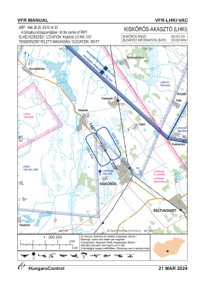
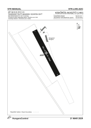


LHKI - Kiskoros/Akaszto
Located in Kiskoros, Hungary
ICAO - , IATA -
Data provided by AirmateGeneral information
Coordinates: N46°39'25" E19°14'33"
Elevation is 305 feet MSL.
View others Airports in Bács-Kiskun
Operational data
Special qualification required
Current time UTC:
Current local time:
Weather at : LHKE - Kecskemet ( 48 km )
METAR: LHKE 280645Z 16010KT CAVOK 16/10 Q1021 NOSIG RMK BLU
TAF: TAF LHKE 280515Z 2806/2815 15006KT CAVOK BECMG 2807/2809 16010KT
Communications frequencies: [VIEW]
Runways:
| RWY identifier | QFU | Length (ft) | Width (ft) | Surface | LDA (ft) |
| 15 | 0° | 1411 | 144 | GRASS | |
| 33 | 0° | 1411 | 144 | GRASS |
Airport contact information
Address: Kiskoros Hungary