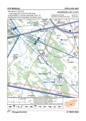
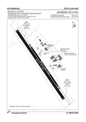


LHJK - Jakabszallas
Located in Jakabszallas, Hungary
ICAO - LHJK, IATA -
Data provided by AirmateGeneral information
Coordinates: N46°44'51" E19°36'26"
Elevation is 364 feet MSL.
View others Airports in Bács-Kiskun
Operational data
Special qualification required
Current time UTC:
Current local time:
Weather at : LHKE - Kecskemet ( 22 km )
METAR: LHKE 040145Z 28009KT CAVOK 13/11 Q1009 NOSIG RMK BLU
TAF: TAF LHKE 032015Z 0321/0406 29007KT CAVOK TEMPO 0322/0402 31011KT BECMG 0402/0405 33006KT
Communications frequencies: [VIEW]
Runways:
| RWY identifier | QFU | Length (ft) | Width (ft) | Surface | LDA (ft) |
| 14L | 0° | 1969 | 59 | ASPH | |
| 32R | 0° | 1969 | 59 | ASPH | |
| 14R | 0° | 3068 | 98 | GRASS | |
| 32L | 0° | 3068 | 98 | GRASS |
Airport contact information
Address: Jakabszallas Hungary