


LHHK - Hajmasker
Located in Hajmasker, Hungary
ICAO - , IATA -
Data provided by AirmateGeneral information
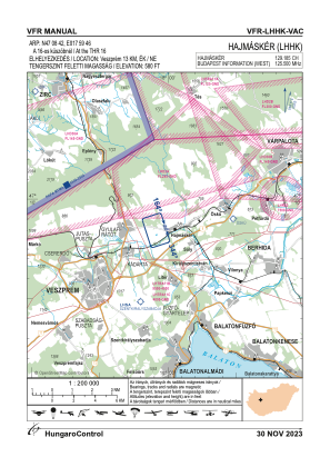
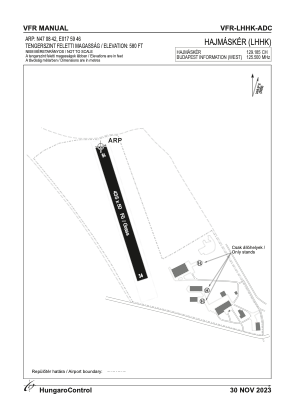
Coordinates: N47°8'42" E17°59'46"
Elevation is 584 feet MSL.
View others Airports in Veszprém
Operational data
Special qualification required
Current time UTC:
Current local time:
Weather at : LHPA - Papa ( 45 km )
TAF: TAF LHPA 212315Z 2200/2224 VRB03KT 9999 SCT030 TEMPO 2200/2207 8000 -RA SHRA BKN030 BKN083 BECMG 2203/2206 31006KT BECMG 2215/2218 CAVOK BECMG 2217/2220 23005KT
Communications frequencies: [VIEW]
Runways:
| RWY identifier | QFU | Length (ft) | Width (ft) | Surface | LDA (ft) |
| 16 | 0° | 1427 | 164 | GRASS | |
| 34 | 0° | 1427 | 164 | GRASS |
Airport contact information
Address: Hajmasker Hungary