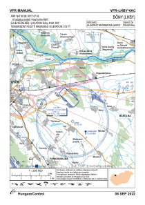


LHBY - Bony
Located in Bony, Hungary
ICAO - , IATA -
Data provided by AirmateGeneral information
Coordinates: N47°40'8" E17°47'5"
Elevation is 512 feet MSL.
View others Airports in Gyor-Moson-Sopron
Operational data
Special qualification required
Current time UTC:
Current local time:
Weather at : LHPR - Gyor/Per ( 5 km )
METAR: LHPR 170615Z AUTO 13018KT 9999 BKN016 13/10 Q1010 NOSIG
TAF: TAF LHPR 170515Z 1706/1715 12015G25KT 9999 SCT012 BKN025 BKN060 TEMPO 1706/1708 15022G32KT 2500 SHRA BKN008 SCT015CB OVC025 PROB30 TEMPO 1706/1708 TSRA TEMPO 1708/1710 BKN008 BKN040 BECMG 1710/1712 SCT030 TEMPO 1712/1715 VRB25G40KT 1200 +TSRAGR BKN020CB
Communications frequencies: [VIEW]
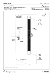
Runways:
| RWY identifier | QFU | Length (ft) | Width (ft) | Surface | LDA (ft) |
| 13 | 0° | 2133 | 197 | GRASS | |
| 31 | 0° | 2133 | 197 | GRASS |
Airport contact information
Address: Bony Hungary