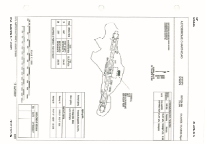


LGKY - Kalymnos
Located in , Greece
ICAO - LGKY, IATA - JKL
Data provided by AirmateGeneral information
Coordinates: N36°57'48" E26°56'26"
Elevation is 770 feet MSL.
View others Airports in Dodecanese
Operational data
Special qualification required
Current time UTC:
Current local time:
Weather at : LGKO - Kos / Ippokratis ( 23 km )
METAR: LGKO 091350Z 14008KT 9999 FEW018 21/14 Q1011
TAF: TAF LGKO 091100Z 0912/1012 14010KT 9999 FEW018 BKN050 BECMG 0918/0920 04010KT FEW025 BECMG 1010/1012 13013KT PROB30 TEMPO 1006/1011 5000 RA FEW020 BKN040
Communications frequencies: [VIEW]
Runways:
| RWY identifier | QFU | Length (ft) | Width (ft) | Surface | LDA (ft) |
| 10 | 102° | 3330 | 98 | UNK | |
| 28 | 282° | 3330 | 98 | UNK |
Airport contact information
Address: Greece
