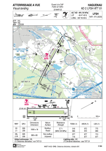


LFSH - Haguenau
Located in Haguenau, France
ICAO - LFSH, IATA -
Data provided by AirmateGeneral information
Coordinates: N48°47'49" E7°49'9"
Elevation is 491 feet MSL.
Magnetic variation is 2.58° East View others Airports in Alsace
Operational data
Special qualification required
Current time UTC:
Current local time:
Weather at : EDSB - Karlsruhe/Baden-Baden ( 19 km )
METAR: EDSB 041650Z VRB01KT CAVOK 18/11 Q1011
TAF: TAF AMD EDSB 041232Z 0412/0512 30004KT CAVOK PROB40 TEMPO 0419/0507 4000 SHRA SCT015 BKN025TCU BECMG 0422/0501 20010KT
Communications frequencies: [VIEW]
Runways:
| RWY identifier | QFU | Length (ft) | Width (ft) | Surface | LDA (ft) |
| 03L | 29° | 2887 | 262 | GRASS | 2329 |
| 21R | 209° | 2887 | 262 | GRASS | 2887 |
| 03 | 29° | 3281 | 59 | ASPH | 2625 |
| 21 | 209° | 3281 | 59 | ASPH | 2930 |
Airport contact information
Address: Haguenau France

