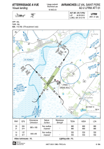


LFRW - Avranches Le Val Saint Pere
Located in , France
ICAO - LFRW, IATA -
Data provided by AirmateGeneral information
Coordinates: N48°39'39" W1°24'21"
Elevation is 25 feet MSL.
Magnetic variation is -0.14° East View others Airports in Lower Normandy
Operational data
Special qualification required
Current time UTC:
Current local time:
Weather at : LFRD - Dinard Pleurtuit Saint Malo ( 50 km )
METAR: LFRD 271500Z AUTO 35006KT 7000 FEW030/// SCT037/// BKN048/// //////TCU 14/11 Q1019 TEMPO 3000 SHRA BKN020CB
TAF: TAF LFRD 271100Z 2712/2812 26010KT 9999 SCT030 TEMPO 2712/2718 3000 SHRA BKN020CB BECMG 2712/2714 30010KT BECMG 2714/2716 VRB05KT BECMG 2720/2722 22010KT BECMG 2722/2724 BKN012 TEMPO 2722/2806 3000 RADZ BKN008 BECMG 2806/2809 BKN018
Communications frequencies: [VIEW]
Runways:
| RWY identifier | QFU | Length (ft) | Width (ft) | Surface | LDA (ft) |
| 14 | 137° | 1804 | 197 | GRASS | |
| 32 | 317° | 1804 | 197 | GRASS | |
| 03 | 34° | 2887 | 354 | GRASS | |
| 21 | 214° | 2887 | 354 | GRASS |
Airport contact information
Address: France
Other aviation service providers
Aviation club (not for profit)

Aéroclub des Grèves du Mont St Michel
Aéroclub des Grèves du Mont St Michel
mesphil@wanadoo.fr+33233580291