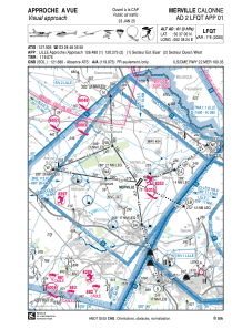
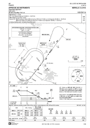
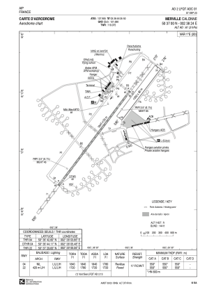


LFQT - Merville Calonne
Located in Merville, France
ICAO - LFQT, IATA - HZB
Data provided by AirmateGeneral information
Coordinates: N50°36'60" E2°38'24"
Elevation is 61 feet MSL.
Magnetic variation is 1.02° East View others Airports in Nord-Pas-de-Calais
Operational data
Special qualification required
Current time UTC:
Current local time:
Weather at : LFQQ - Lille Lesquin ( 32 km )
METAR: LFQQ 051030Z AUTO 14005KT 090V230 9999 BKN037 17/09 Q1009 TEMPO 3000 SHRA BKN013 BKN020TCU
TAF: TAF LFQQ 050500Z 0506/0612 VRB03KT 4500 BR NSC BECMG 0506/0507 9999 NSW PROB40 TEMPO 0512/0518 3000 SHRA BKN013 BKN020TCU TEMPO 0600/0611 3000 RADZ BKN009 OVC014
Communications frequencies: [VIEW]
Runways:
| RWY identifier | QFU | Length (ft) | Width (ft) | Surface | LDA (ft) |
| 04R | 37° | 3281 | 262 | GRASS | 3281 |
| 22L | 217° | 3281 | 262 | GRASS | 3281 |
| 04 | 37° | 6037 | 98 | ASPH | 5840 |
| 22 | 217° | 6037 | 98 | ASPH | 5643 |
Airport contact information
Address: Merville France


