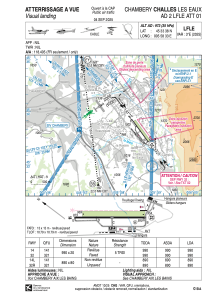


LFLE - Chambery Challes Les Eaux
Located in Chambery, France
ICAO - LFLE, IATA -
Data provided by AirmateGeneral information
Coordinates: N45°33'38" E5°58'33"
Elevation is 973 feet MSL.
Magnetic variation is 2.11° East View others Airports in Rhône Alpes
Operational data
Special qualification required
Current time UTC:
Current local time:
Weather at : LFLB - Chambery Aix Les Bains ( 11 km )
METAR: LFLB 180430Z AUTO 16002KT 1700 0600 R18/2400D R36/3300U BCFG VV/// 08/08 Q1013 TEMPO 0400 BCFG BECMG NSC
Communications frequencies: [VIEW]
Runways:
| RWY identifier | QFU | Length (ft) | Width (ft) | Surface | LDA (ft) |
| 14 | 144° | 3248 | 66 | ASPH | |
| 32 | 324° | 3248 | 66 | ASPH | |
| 14L | 144° | 2920 | 262 | GRASS | |
| 32R | 324° | 2920 | 262 | GRASS |
Airport contact information
Address: Chambery France
Fuel provider

Other aviation service providers
Flight schools

Aviation club (not for profit)

Centre Savoyard de Vol à Voile
Centre Savoyard de Vol à Voile
secretariat@planeur-challes.fr+33479729719
