


LFIT - Toulouse Bourg Saint Bernard
Located in , France
ICAO - LFIT, IATA -
Data provided by AirmateGeneral information
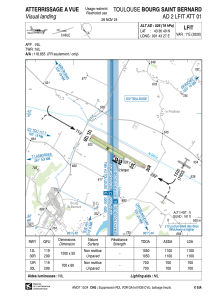
Coordinates: N43°36'40" E1°43'27"
Elevation is 526 feet MSL.
Magnetic variation is 1.06° East View others Airports in Midi-Pyrénées
Operational data
Special qualification required
Current time UTC:
Current local time:
Weather at : LFBO - Toulouse Blagnac ( 29 km )
METAR: LFBO 280530Z AUTO 17003KT 9999 FEW019 BKN049 OVC058 10/08 Q1012 TEMPO BKN014
TAF: TAF LFBO 280500Z 2806/2912 VRB03KT 9999 SCT030 BKN040 TEMPO 2806/2811 BKN020 PROB30 TEMPO 2806/2809 BKN013 TEMPO 2814/2818 01010KT TEMPO 2904/2912 RA BKN013 BKN030 OVC050
Communications frequencies: [VIEW]
Runways:
| RWY identifier | QFU | Length (ft) | Width (ft) | Surface | LDA (ft) |
| 12R | 120° | 2297 | 197 | GRASS | 2297 |
| 30L | 300° | 2297 | 197 | GRASS | 2297 |
| 12L | 120° | 3937 | 164 | GRASS | 3609 |
| 30R | 300° | 3937 | 164 | GRASS | 3609 |
Airport contact information
Address: France
