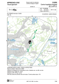


LFH481 - Flers Centre Hospitalier
Located in , France
ICAO - , IATA -
Data provided by AirmateGeneral information
Coordinates: N48°44'58" W0°32'20"
Elevation is 712 feet MSL.
View others Airports in Lower Normandy
Operational data
Special qualification required
Current time UTC:
Current local time:
Weather at : LFRK - Caen Carpiquet ( 48 km )
METAR: LFRK 291500Z AUTO 21009KT 160V240 CAVOK 18/06 Q1016 NOSIG
TAF: TAF LFRK 291400Z 2915/2924 19010KT CAVOK PROB30 TEMPO 2918/2920 4500 -SHRA
Communications frequencies: [VIEW]
Runways:
Airport contact information
Address: France