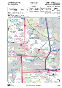


LFH411 - Saint Cyr L'ecole
Located in , France
ICAO - , IATA -
Data provided by AirmateGeneral information
Coordinates: N48°48'54" E2°3'55"
Elevation is 362 feet MSL.
Magnetic variation is 0.94° East View others Airports in Île-de-France
Operational data
Special qualification required
Current time UTC:
Current local time:
Weather at : LFPN - Toussus Le Noble ( 8 km )
METAR: LFPN 272030Z AUTO 17008KT 9999 RA FEW011/// BKN066/// OVC084/// ///CB 11/11 Q1000 BECMG NSW SCT030 BKN050
TAF: TAF LFPN 271700Z 2718/2803 13012KT 9999 SCT030 BKN050 TEMPO 2718/2721 4000 SHRA BKN030TCU PROB40 TEMPO 2718/2720 TSRA BKN020CB BECMG 2720/2722 18010KT
Communications frequencies: [VIEW]
Runways:
Airport contact information
Address: France