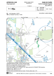


LFH173 - Rang Du Fliers Centre Hospitalier
Located in , France
ICAO - , IATA -
Data provided by AirmateGeneral information
Coordinates: N50°24'52" E1°39'47"
Elevation is 152 feet MSL.
Magnetic variation is 0.72° East View others Airports in Nord-Pas-de-Calais
Operational data
Special qualification required
Current time UTC:
Current local time:
Weather at : LFAT - Le Touquet Cote D'opale ( 11 km )
METAR: LFAT 110430Z AUTO 08008KT 8000 NSC 13/10 Q1020
Communications frequencies: [VIEW]
Runways:
Airport contact information
Address: France