


LFES - Guiscriff Scaer
Located in , France
ICAO - LFES, IATA -
Data provided by AirmateGeneral information
Coordinates: N48°3'13" W3°39'51"
Elevation is 574 feet MSL.
Magnetic variation is -0.83° East View others Airports in Brittany
Operational data
Special qualification required
Current time UTC:
Current local time:
Weather at : LFRH - Lorient Lann Bihoue ( 37 km )
METAR: LFRH 150030Z AUTO 18008KT 9999 BKN011/// BKN018/// BKN031/// ///TCU 12/11 Q1000 BECMG BKN018
TAF: TAF LFRH 142300Z 1500/1524 19010KT 9999 BKN018 TEMPO 1420/1422 18010KT SHRA SCT010TCU BKN013 TEMPO 1422/1509 SHRA SCT009CB BKN013 PROB30 TEMPO 1503/1507 4000 TSRA SCT009CB BKN014 TEMPO 1509/1518 18015G25KT SHRA SCT014CB BKN018
Communications frequencies: [VIEW]
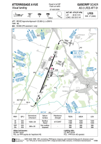
Runways:
| RWY identifier | QFU | Length (ft) | Width (ft) | Surface | LDA (ft) |
| 02 | 23° | 4921 | 98 | ASPH | 4921 |
| 20 | 203° | 4921 | 98 | ASPH | 4921 |
| 02R | 23° | 984 | 66 | GRASS | |
| 20L | 203° | 984 | 66 | GRASS |
Airport contact information
Address: France

