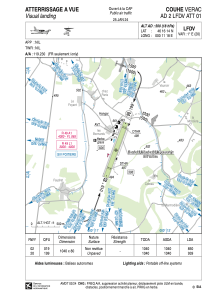


LFDV - Couhe Verac
Located in Couhe, France
ICAO - LFDV, IATA -
Data provided by AirmateGeneral information
Coordinates: N46°16'14" E0°11'18"
Elevation is 500 feet MSL.
Magnetic variation is 0.52° East View others Airports in Poitou-Charentes
Operational data
Special qualification required
Current time UTC:
Current local time:
Weather at : LFBI - Poitiers Biard ( 36 km )
METAR: LFBI 291430Z AUTO 17003KT 100V260 CAVOK 16/07 Q1018 NOSIG
TAF: TAF LFBI 291100Z 2912/3012 17004KT CAVOK TEMPO 3004/3007 3000 BR
Communications frequencies: [VIEW]
Runways:
| RWY identifier | QFU | Length (ft) | Width (ft) | Surface | LDA (ft) |
| 02 | 20° | 3412 | 262 | GRASS | 2789 |
| 20 | 200° | 3412 | 262 | GRASS | 3081 |
| 02R | 0° | 1663 | 66 | GRASS | |
| 20L | 0° | 1663 | 66 | GRASS |
Airport contact information
Address: Couhe France
Other aviation service providers
Aviation club (not for profit)

Aéroclub Couhé-Brux et du Civraisien
Aéroclub Couhé-Brux et du Civraisien
aeroclub-couhe-verac@wanadoo.fr+33549379798