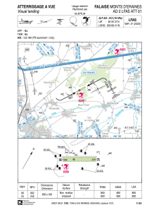


LFAS - Falaise Monts D'eraines
Located in , France
ICAO - LFAS, IATA -
Data provided by AirmateGeneral information
Coordinates: N48°55'37" W0°8'41"
Elevation is 513 feet MSL.
Magnetic variation is 0.24° East View others Airports in Lower Normandy
Operational data
Special qualification required
Current time UTC:
Current local time:
Weather at : LFRK - Caen Carpiquet ( 35 km )
METAR: LFRK 181400Z AUTO 01011KT 340V040 CAVOK 18/12 Q1013 NOSIG
TAF: TAF LFRK 181100Z 1812/1821 35006KT 9999 SCT025 PROB30 TEMPO 1812/1814 4000 -SHRA SCT030CB PROB30 TEMPO 1819/1821 4000 BR BKN005
Communications frequencies: [VIEW]
Runways:
| RWY identifier | QFU | Length (ft) | Width (ft) | Surface | LDA (ft) |
| 06 | 62° | 2789 | 328 | GRASS | 2789 |
| 24 | 242° | 2789 | 328 | GRASS | 2789 |
Airport contact information
Address: France

