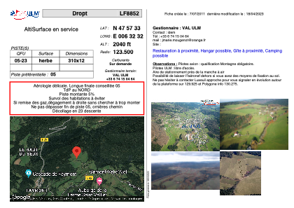


LF8852 - Dropt
Located in Girmont-Val-d'Ajol, France
ICAO - , IATA -
Data provided by AirmateGeneral information
Coordinates: N47°57'33" E6°32'32"
Elevation is 2040 feet MSL.
View others Airports in Lorraine
Operational data
Special qualification required
Current time UTC:
Current local time:
Weather at : LFSX - Luxeuil Saint Sauveur ( 23 km )
TAF: TAF LFSX 232000Z 2321/2421 15003KT 9999 SCT030 BECMG 2323/2401 2000 BR BKN002 TEMPO 2401/2404 0900 FG VV/// BECMG 2404/2406 9999 NSW SCT015 TEMPO 2407/2420 4000 SHRA SCT015TCU PROB40 TEMPO 2411/2420 2000 TSRA SCT015CB
Communications frequencies: [VIEW]
Runways:
| RWY identifier | QFU | Length (ft) | Width (ft) | Surface | LDA (ft) |
| 05 | 0° | 1017 | 39 | GRASS | |
| 23 | 0° | 1017 | 39 | GRASS |
Airport contact information
Address: Girmont-Val-d'Ajol France