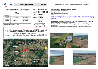


LF8266 - Bourg de Visa
Located in Bourg-de-Visa, France
ICAO - , IATA -
Data provided by AirmateGeneral information
Coordinates: N44°14'1" E0°56'45"
Elevation is 707 feet MSL.
View others Airports in Aquitaine
Operational data
Special qualification required
Current time UTC:
Current local time:
Weather at : LFBA - Agen La Garenne ( 29 km )
METAR: LFBA 180000Z AUTO VRB03KT 9999 ///TCU 13/10 Q1012
TAF: TAF LFBA 171400Z 1715/1724 30005KT CAVOK PROB40 TEMPO 1715/1720 SHRA SCT035TCU BKN080 PROB30 TEMPO 1716/1719 4000 -TSRA SCT025CB BKN035 BECMG 1718/1720 VRB03KT
Communications frequencies: [VIEW]
Runways:
| RWY identifier | QFU | Length (ft) | Width (ft) | Surface | LDA (ft) |
| 13 | 0° | 974 | 65 | GRASS | |
| 31 | 0° | 974 | 65 | GRASS |
Airport contact information
Address: Bourg-de-Visa France