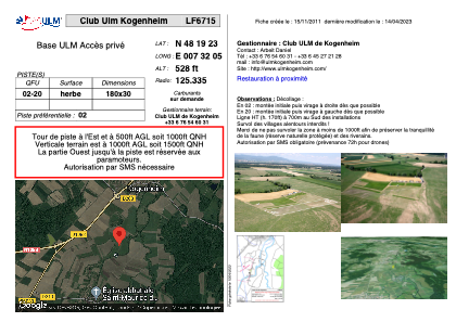


LF6715 - Club Ulm Kogenheim
Located in Kogenheim, France
ICAO - , IATA -
Data provided by AirmateGeneral information
Coordinates: N48°19'23" E7°32'5"
Elevation is 528 feet MSL.
View others Airports in Alsace
Operational data
Special qualification required
Current time UTC:
Current local time:
Weather at : EDTL - Lahr ( 22 km )
METAR: EDTL 100620Z 00000KT CAVOK 13/09 Q1022
TAF: TAF EDTL 100603Z 1007/1015 02004KT CAVOK BECMG 1009/1011 01009KT
Communications frequencies: [VIEW]
Runways:
| RWY identifier | QFU | Length (ft) | Width (ft) | Surface | LDA (ft) |
| 02 | 0° | 590 | 98 | GRASS | |
| 20 | 0° | 590 | 98 | GRASS |
Airport contact information
Address: Kogenheim France