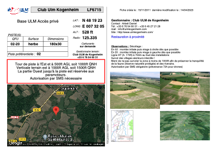


LF6715 - Club Ulm Kogenheim
Located in Kogenheim, France
ICAO - , IATA -
Data provided by AirmateGeneral information
Coordinates: N48°19'23" E7°32'5"
Elevation is 528 feet MSL.
View others Airports in Alsace
Operational data
Special qualification required
Current time UTC:
Current local time:
Weather at : EDTL - Lahr ( 22 km )
METAR: EDTL 180850Z 19006KT 150V240 CAVOK 18/11 Q1012
TAF: TAF EDTL 180800Z 1809/1818 23006KT 9999 SCT020 PROB40 TEMPO 1813/1818 SHRA BKN020CB PROB30 TEMPO 1814/1817 4500 TSRA BKN014CB
Communications frequencies: [VIEW]
Runways:
| RWY identifier | QFU | Length (ft) | Width (ft) | Surface | LDA (ft) |
| 02 | 0° | 590 | 98 | GRASS | |
| 20 | 0° | 590 | 98 | GRASS |
Airport contact information
Address: Kogenheim France