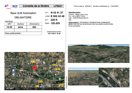


LF6631 - Corneilla de la Rivière
Located in Corneilla-de-la-Rivière, France
ICAO - , IATA -
Data provided by AirmateGeneral information
Coordinates: N42°41'27" E2°43'49"
Elevation is 230 feet MSL.
View others Airports in Languedoc-Roussillon
Operational data
Special qualification required
Current time UTC:
Current local time:
Weather at : LFMP - Perpignan Rivesaltes ( 13 km )
METAR: LFMP 142300Z AUTO 27005KT 9999 SCT086 14/10 Q1007
TAF: TAF LFMP 141400Z 1415/1515 28008KT 9999 SCT035TCU OVC040 TEMPO 1415/1416 4500 RA SCT012 BKN030 FEW035CB PROB40 TEMPO 1415/1416 2500 +TSRA BKN012 BECMG 1416/1418 NSC
Communications frequencies: [VIEW]
Runways:
| RWY identifier | QFU | Length (ft) | Width (ft) | Surface | LDA (ft) |
| 12 | 0° | 820 | 0 | DIRT | |
| 30 | 0° | 820 | 0 | DIRT |
Airport contact information
Address: Corneilla-de-la-Rivière France