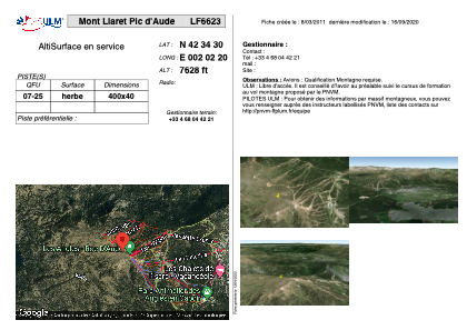


LF6623 - Mont Llaret Pic d'Aude
Located in Les Angles, France
ICAO - , IATA -
Data provided by AirmateGeneral information
Coordinates: N42°34'30" E2°2'20"
Elevation is 7628 feet MSL.
View others Airports in Languedoc-Roussillon
Operational data
Special qualification required
Current time UTC:
Current local time:
Weather at : LESU - Andorra-La Seu D'urgell ( 58 km )
METAR: LESU 241800Z VRB01KT 9999 SCT051 14/12 Q1018
TAF: TAF LESU 241400Z 2415/2515 VRB04KT 9999 SCT020 TX25/2514Z TN05/2505Z TEMPO 2415/2422 3000 SHRA BKN010 FEW030TCU PROB40 TEMPO 2415/2421 3000 TSRA BKN010 FEW030CB TEMPO 2415/2418 22010KT BECMG 2510/2512 20009KT
Communications frequencies: [VIEW]
Runways:
| RWY identifier | QFU | Length (ft) | Width (ft) | Surface | LDA (ft) |
| 07 | 0° | 1312 | 131 | GRASS | |
| 25 | 0° | 1312 | 131 | GRASS |
Airport contact information
Address: Les Angles France