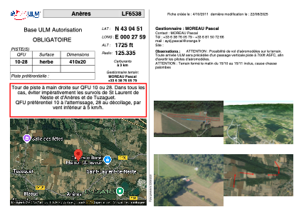


LF6538 - Anères
Located in Loures-Barousse, France
ICAO - , IATA -
Data provided by AirmateGeneral information
Coordinates: N43°4'51" E0°27'59"
Elevation is 1600 feet MSL.
View others Airports in Midi-Pyrénées
Operational data
Special qualification required
Current time UTC:
Current local time:
Communications frequencies: [VIEW]
Runways:
| RWY identifier | QFU | Length (ft) | Width (ft) | Surface | LDA (ft) |
| 09 | 0° | 1312 | 49 | GRASS | |
| 27 | 0° | 1312 | 49 | GRASS |
Airport contact information
Address: Loures-Barousse France