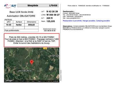


LF6458 - Mesplède
Located in Mesplede, France
ICAO - , IATA -
Data provided by AirmateGeneral information
Coordinates: N43°30'39" W0°39'27"
Elevation is 320 feet MSL.
View others Airports in Aquitaine
Operational data
Special qualification required
Current time UTC:
Current local time:
Weather at : LFBP - Pau Pyrenees ( 24 km )
METAR: LFBP 180000Z AUTO 16001KT 9999 FEW017/// SCT048/// BKN072/// 12/11 Q1012 NOSIG
TAF: TAF LFBP 172300Z 1800/1824 VRB03KT 9999 BKN030 PROB30 TEMPO 1803/1807 4000 MIFG BKN012 PROB30 TEMPO 1811/1819 -SHRA SCT030TCU PROB40 TEMPO 1819/1821 3000 TSRA BKN014 BKN020TCU SCT025CB PROB40 1822/1824 4000 BR BKN012
Communications frequencies: [VIEW]
Runways:
| RWY identifier | QFU | Length (ft) | Width (ft) | Surface | LDA (ft) |
| 15 | 0° | 984 | 65 | GRASS | |
| 33 | 0° | 984 | 65 | GRASS |
Airport contact information
Address: Mesplede France
Web: www.autogire64-65.fr