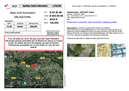


LF6358 - Sailles Saint-Nectaire
Located in Saint-Nectaire, France
ICAO - , IATA -
Data provided by AirmateGeneral information
Coordinates: N45°35'46" E3°0'9"
Elevation is 3018 feet MSL.
View others Airports in Auvergne
Operational data
Special qualification required
Current time UTC:
Current local time:
Weather at : LFLC - Clermont Ferrand Auvergne ( 24 km )
TAF: TAF AMD LFLC 181142Z 1812/1912 VRB04KT 9999 BKN030 TEMPO 1812/1820 36010KT 4000 SHRA SCT040TCU PROB30 TEMPO 1812/1819 -TSRA SCT020CB PROB40 TEMPO 1823/1908 0800 FG VV/// BECMG 1908/1910 06008KT TEMPO 1910/1912 FEW050TCU
Communications frequencies: [VIEW]
Runways:
| RWY identifier | QFU | Length (ft) | Width (ft) | Surface | LDA (ft) |
| 12 | 0° | 656 | 82 | GRASS | |
| 30 | 0° | 656 | 82 | GRASS |
Airport contact information
Address: Saint-Nectaire France