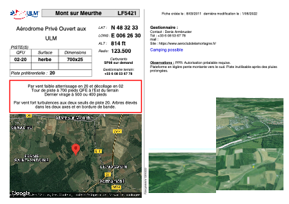


LF5421 - Mont sur Meurthe
Located in Mont-sur-Meurthe, France
ICAO - , IATA -
Data provided by AirmateGeneral information
Coordinates: N48°32'33" E6°26'30"
Elevation is 814 feet MSL.
View others Airports in Lorraine
Operational data
Special qualification required
Current time UTC:
Current local time:
Weather at : LFSN - Nancy Essey ( 23 km )
METAR: LFSN 231330Z AUTO 05003KT 020V080 9999 BKN048/// BKN054/// OVC088/// ///CB 20/09 Q1016
Communications frequencies: [VIEW]
Runways:
| RWY identifier | QFU | Length (ft) | Width (ft) | Surface | LDA (ft) |
| 02 | 0° | 2296 | 82 | GRASS | |
| 20 | 0° | 2296 | 82 | GRASS |
Airport contact information
Address: Mont-sur-Meurthe France