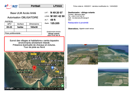


LF5022 - Portbail
Located in Portbail-sur-Mer, France
ICAO - , IATA -
Data provided by AirmateGeneral information
Coordinates: N49°20'7" W1°42'50"
Elevation is 49 feet MSL.
View others Airports in Lower Normandy
Operational data
Special qualification required
Current time UTC:
Current local time:
Weather at : EGJJ - Jersey ( 38 km )
METAR: EGJJ 150620Z 14015KT 9999 BKN009 12/10 Q1001
TAF: TAF EGJJ 150456Z 1506/1515 15014KT 9999 FEW010 SCT020 TEMPO 1506/1510 FEW006 BKN008 PROB40 TEMPO 1510/1515 14016G26KT 6000 SHRA FEW012 BKN020TCU PROB30 TEMPO 1512/1515 4000 +SHRA FEW010 BKN014CB
Communications frequencies: [VIEW]
Runways:
| RWY identifier | QFU | Length (ft) | Width (ft) | Surface | LDA (ft) |
| 05 | 0° | 524 | 98 | GRASS | |
| 23 | 0° | 524 | 98 | GRASS |
Airport contact information
Address: Portbail-sur-Mer France
Web: www.ulm-portbail.fr