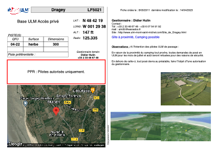


LF5021 - Dragey
Located in Dragey, France
ICAO - , IATA -
Data provided by AirmateGeneral information
Coordinates: N48°42'19" W1°29'38"
Elevation is 147 feet MSL.
View others Airports in Lower Normandy
Operational data
Special qualification required
Current time UTC:
Current local time:
Weather at : LFRD - Dinard Pleurtuit Saint Malo ( 45 km )
METAR: LFRD 211630Z AUTO 31009KT CAVOK 17/13 Q1011 TEMPO BKN008
TAF: TAF LFRD 211100Z 2112/2212 VRB05KT 9999 BKN030 BECMG 2112/2114 32010KT TEMPO 2112/2116 3000 SHRA BKN008 BKN020CB TEMPO 2116/2208 BKN008 BECMG 2122/2124 26010KT BECMG 2210/2212 32010KT PROB40 TEMPO 2210/2212 3000 SHRA BKN020CB
Communications frequencies: [VIEW]
Runways:
| RWY identifier | QFU | Length (ft) | Width (ft) | Surface | LDA (ft) |
| 04 | 0° | 984 | 0 | GRASS | |
| 22 | 0° | 984 | 0 | GRASS |
Airport contact information
Address: Dragey France