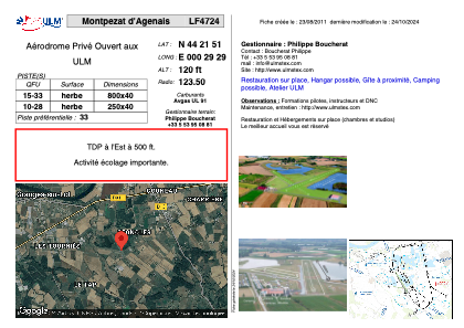


LF4724 - Montpezat d'Agenais
Located in Montpezat, France
ICAO - , IATA -
Data provided by AirmateGeneral information
Coordinates: N44°21'51" E0°29'29"
Elevation is 120 feet MSL.
View others Airports in Aquitaine
Operational data
Special qualification required
Current time UTC:
Current local time:
Weather at : LFBA - Agen La Garenne ( 22 km )
METAR: LFBA 281630Z AUTO 30003KT 270V360 CAVOK 20/07 Q1014 TEMPO SCT035TCU SCT045
TAF: TAF LFBA 281400Z 2815/2824 VRB03KT 9999 FEW023 BKN032 OVC044 TEMPO 2815/2818 -SHRA SCT035TCU SCT045
Communications frequencies: [VIEW]
Runways:
| RWY identifier | QFU | Length (ft) | Width (ft) | Surface | LDA (ft) |
| 15 | 0° | 2624 | 131 | GRASS | |
| 33 | 0° | 2624 | 131 | GRASS |
Airport contact information
Address: Montpezat France
