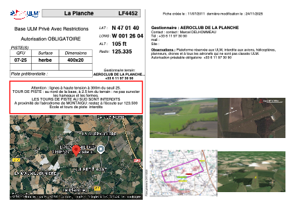


LF4452 - La Planche
Located in La Planche, France
ICAO - , IATA -
Data provided by AirmateGeneral information
Coordinates: N47°1'40" W1°26'4"
Elevation is 105 feet MSL.
View others Airports in Pays-de-la-Loire
Operational data
Special qualification required
Current time UTC:
Current local time:
Weather at : LFRS - Nantes Atlantique ( 19 km )
METAR: LFRS 011200Z AUTO VRB03KT 9999 FEW045 OVC110 12/08 Q1008 TEMPO 4000 SHRA BKN025TCU
TAF: TAF LFRS 011100Z 0112/0218 VRB03KT 9999 BKN030 TEMPO 0112/0118 4000 SHRA BKN025TCU BECMG 0118/0120 28010KT TEMPO 0208/0215 27015G25KT 4000 SHRA BKN020TCU
Communications frequencies: [VIEW]
Runways:
| RWY identifier | QFU | Length (ft) | Width (ft) | Surface | LDA (ft) |
| 07 | 0° | 1312 | 65 | GRASS | |
| 25 | 0° | 1312 | 65 | GRASS |
Airport contact information
Address: La Planche France