


LF4157 - Selles Saint Denis
Located in Selles-Saint-Denis, France
ICAO - , IATA -
Data provided by AirmateGeneral information
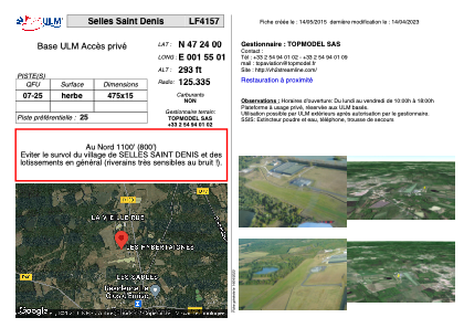
Coordinates: N47°24'0" E1°55'1"
Elevation is 293 feet MSL.
View others Airports in Centre
Operational data
Special qualification required
Current time UTC:
Current local time:
Weather at : LFYR - Romorantin Pruniers ( 19 km )
METAR: LFYR 240630Z AUTO VRB02KT 9999 FEW006 OVC072 13/12 Q1018 TEMPO 3000 SHRA BKN005 BKN040TCU
TAF: TAF AMD LFYR 240530Z 2405/2503 VRB02KT 9999 SCT015 PROB30 TEMPO 2406/2408 3000 SHRA BKN005 BKN040TCU TEMPO 2410/2419 VRB15G30KT 4000 SHRA SCT010 BKN030CB PROB40 TEMPO 2412/2419 1500 TSRAGS BKN008 BKN025CB BECMG 2422/2424 0800 FG VV///
Communications frequencies: [VIEW]
Runways:
| RWY identifier | QFU | Length (ft) | Width (ft) | Surface | LDA (ft) |
| 07 | 0° | 1558 | 49 | GRASS | |
| 25 | 0° | 1558 | 49 | GRASS |
Airport contact information
Address: Selles-Saint-Denis France