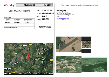


LF3558 - Queneleuc
Located in Saint-Malon-sur-Mel, France
ICAO - , IATA -
Data provided by AirmateGeneral information
Coordinates: N48°5'54" W2°4'35"
Elevation is 246 feet MSL.
View others Airports in Brittany
Operational data
Special qualification required
Current time UTC:
Current local time:
Weather at : LFRN - Rennes Saint Jacques ( 26 km )
METAR: LFRN 290630Z AUTO 18003KT 140V200 0500 0400 R28/0800U R10/0800N FG VV/// 07/07 Q1017 BECMG 9999 NSW SCT025
TAF: TAF LFRN 290500Z 2906/3006 VRB03KT 3000 BR BKN005 PROB40 TEMPO 2906/2907 0400 FG VV/// BECMG 2907/2909 20010KT 9999 NSW SCT025 BECMG 2922/2924 VRB05KT 3000 BR PROB40 TEMPO 3003/3006 0600 FG VV///
Communications frequencies: [VIEW]
Runways:
| RWY identifier | QFU | Length (ft) | Width (ft) | Surface | LDA (ft) |
| 06 | 0° | 885 | 88 | GRASS | |
| 24 | 0° | 885 | 88 | GRASS |
Airport contact information
Address: Saint-Malon-sur-Mel France