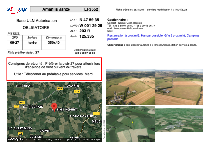


LF3552 - Amanlis Janzé
Located in Amanlis, France
ICAO - , IATA -
Data provided by AirmateGeneral information
Coordinates: N47°59'35" W1°29'29"
Elevation is 203 feet MSL.
Magnetic variation is 0° East View others Airports in Brittany
Operational data
Special qualification required
Current time UTC:
Current local time:
Weather at : LFRN - Rennes Saint Jacques ( 20 km )
TAF: TAF LFRN 272300Z 2800/2824 30010KT 9999 BKN020 TEMPO 2800/2802 3000 RA BKN005 BKN015CB BECMG 2802/2804 24010KT PROB40 TEMPO 2802/2808 BKN008 TEMPO 2810/2820 3000 SHRA BKN012 BKN020CB PROB40 TEMPO 2812/2817 VRB15G25KT 1500 TSRAGS BECMG 2817/2819 VRB05KT BECMG 2822/2824 3000 BR
Communications frequencies: [VIEW]
Runways:
| RWY identifier | QFU | Length (ft) | Width (ft) | Surface | LDA (ft) |
| 09 | 0° | 1148 | 131 | GRASS | |
| 27 | 0° | 1148 | 131 | GRASS |
Airport contact information
Address: Amanlis France