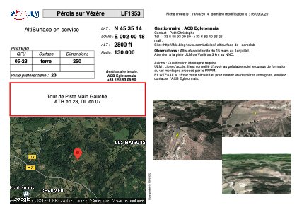


LF1953 - Pérols sur Vézère
Located in Pérols-sur-Vézère, France
ICAO - , IATA -
Data provided by AirmateGeneral information
Coordinates: N45°35'14" E2°0'48"
Elevation is 2800 feet MSL.
View others Airports in Limousin
Operational data
Special qualification required
Current time UTC:
Current local time:
Weather at : LFBL - Limoges Bellegarde ( 71 km )
METAR: LFBL 042230Z AUTO 20008KT 170V230 3600 -RA BR BKN005/// BKN011/// OVC019/// ///CB 13/13 Q1013 TEMPO 2000 RA OVC003
TAF: TAF LFBL 041700Z 0418/0518 19010KT 9999 BKN010 TEMPO 0418/0504 2000 RA OVC003 PROB40 TEMPO 0418/0422 19010G20KT TEMPO 0504/0507 3000 BR BKN005 BECMG 0507/0509 SCT010 BKN040 TEMPO 0511/0518 3000 SHRA BKN020TCU PROB30 TEMPO 0514/0517 22015G25KT 1000 -TSRAGS BKN010 BKN020CB
Communications frequencies: [VIEW]
Runways:
| RWY identifier | QFU | Length (ft) | Width (ft) | Surface | LDA (ft) |
| 05 | 0° | 820 | 0 | DIRT | |
| 23 | 0° | 820 | 0 | DIRT |
Airport contact information
Address: Pérols-sur-Vézère France