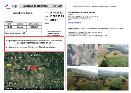


LF1222 - La Brousse Golinhac
Located in Golinhac, France
ICAO - , IATA -
Data provided by AirmateGeneral information
Coordinates: N44°34'52" E2°35'29"
Elevation is 2185 feet MSL.
View others Airports in Midi-Pyrénées
Operational data
Special qualification required
Current time UTC:
Current local time:
Weather at : LFCR - Rodez Aveyron ( 21 km )
METAR: LFCR 282300Z AUTO 04006KT 360V070 9999 -RA BKN006/// BKN010/// BKN020/// ///TCU 10/09 Q1018 TEMPO 4000 RA BKN013 SCT020TCU OVC030
TAF: TAF AMD LFCR 281925Z 2819/2918 VRB03KT 9999 BKN046 BKN056 OVC080 TEMPO 2819/2918 -RA BKN013 SCT020TCU OVC030 PROB30 TEMPO 2900/2916 4000 RA BKN007
Communications frequencies: [VIEW]
Runways:
Airport contact information
Address: Golinhac France